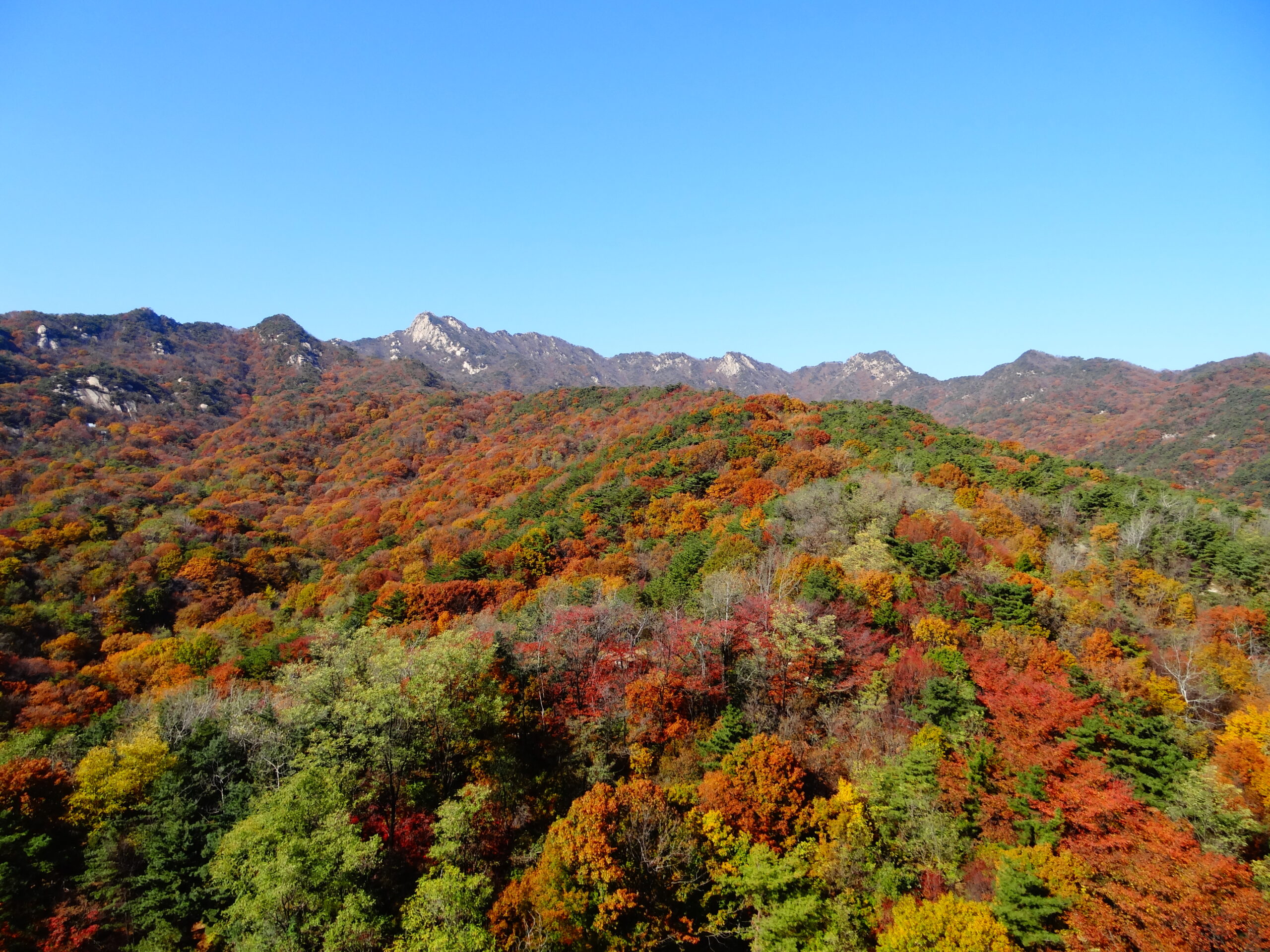
Last checked: October 24, 2026 (KST), against Korea National Park Service (KNPS) course pages and trail-hour rules, the 2026 autumn fire-season closure list, the Seoul Hiking Tourism Center guide and Seoul’s official fare tables. Conditions on a mountain change quickly; the official links are listed at the end. Bukhansan is the mountain you can see from downtown Seoul, and you can stand on its highest peak, Baegundae (836.5 m), and be back on the subway the same afternoon. The shortest official route from the Baegun Visitor Center is 1.9 km one way (about 1 hour 30 minutes), and the classic route from Bukhansanseong is 3.4 km (about 2 hours 40 minutes). Entry is free and no booking is needed, but trails close to new hikers at 17:00 through November, the last stretch to the summit is steep granite with wire ropes, and from November 15 to December 15 some national park trails close for fire season. KMA reported the first fall color on Bukhansan on October 14, 2026, so late October and early November are the time to go.
| Quick facts | Details |
|---|---|
| Highest peak | Baegundae, 836.5 m (KNPS) |
| Entry fee / booking | None for day hiking |
| Shortest summit route | Baegun Visitor Center → Haroojae → Baegun Shelter → Baegundae: 1.9 km one way, about 1 h 30 min |
| Classic summit route | Bukhansanseong Visitor Center → Daeseomun → Borisa → Baegundae: 3.4 km one way, about 2 h 40 min |
| Trail entry hours | 04:00–17:00 (March–November), 04:00–16:00 (December–February) at Bukhansan control points |
| Nearest stations | Bukhansan Ui Station (Ui LRT) for the Ui side; Gupabal Station (Line 3) + bus for the Bukhansanseong side |
| Fall color | First foliage observed October 14, 2026 (Korea Meteorological Administration) |
| Fire-season closures | National parks: November 15–December 15, 2026 (selected sections only) |
| Gear help | Seoul Hiking Tourism Center (Bukhansan), Exit 2 of Bukhansan Ui Station, gear rental for foreign visitors |
1. Is Bukhansan Worth It on a Seoul Trip?
If you have one free day in Seoul and like walking, Bukhansan gives you something a palace cannot: a granite summit with a view across the whole city, reached by public transport from your hotel. It is a national park inside the metropolitan area, so the trailheads have convenience stores, toilets, outdoor shops and buses back to the subway. Three things make late October to mid-November a good window in 2026:
- Color is arriving. The Korea Meteorological Administration (KMA) said on October 15 that about 20% of Bukhansan, counted from the summit down, had turned on October 14, which is its definition of “first foliage.” KMA calls a mountain “at peak” when about 80% has turned. Check KMA’s famous-mountain foliage page before you pick a date.
- Trails are still open late. Bukhansan’s control points let hikers start until 17:00 through November; from December the cut-off moves to 16:00.
- Fire-season closures are limited here. The 2026 autumn closure list for national parks runs November 15 to December 15, and Bukhansan has very few controlled sections compared with larger parks.
Who should skip the summit? If you are not comfortable on steep rock with fixed wire ropes, or if it has rained or frozen overnight, choose one of the easier routes in Section 4. The final 300 m to Baegundae is narrow and crowded on weekends, and KNPS warns that waiting at the top can delay you significantly.
2. How to Get to Bukhansan by Subway and Bus
There are two main approaches to Baegundae. Pick the one that matches the route you want, or go up one side and down the other.
| Trailhead | How to get there | Walk to the trail | Best for |
|---|---|---|---|
| Ui side (Baegun Visitor Center) | Ui LRT to Bukhansan Ui Station (the line’s last stop). The Ui LRT connects with Line 1 and Line 2 at Sinseol-dong, Line 4 at Sungshin Women’s University and Line 6 at Bomun | KNPS lists the road from the Ui ranger post to Doseon Plaza as 2.0 km, about 30 minutes, uphill on asphalt | Shortest climb to Baegundae; Seoul Hiking Tourism Center is next to the station |
| Bukhansanseong side | Line 3 to Gupabal Station, Exit 1 or 2, then bus 704 or Yangju 37 to “Bukhansanseong Entrance” (KNPS directions) | About 10 minutes on foot from the bus stop to the Bukhansanseong Visitor Center (45 Daeseomun-gil, Eunpyeong-gu) | Fortress gates, valley scenery, the gentle Daenammun route |
| Jeongneung side | Ui LRT to Bukhansan Bogungmun Station, then walk or local bus to the Jeongneung Visitor Center | Varies | Short climb to Bogungmun Gate on the fortress wall |
Fares in Seoul (adult, transit card, as listed by Seoul’s public price pages): subway base fare 1,550 won, city (blue/green) bus 1,500 won, with transfer discounts when you tap in and out. A single-journey subway ticket costs more than a card fare, so use T-money or a Climate Card. Taxis from Bukhansan Ui Station to the temple road are an option when you are short on time, but we did not find an official fare to quote. A practical tip for the Bukhansanseong side: on fine autumn weekends, buses from Gupabal and the trailhead parking lot can be crowded, so an early start helps. The KNPS ranger program notice for 2026 also says Daeseomun Gate is under construction and cannot be visited as part of that program, so expect works near the gate on the classic route and follow on-site signs.
3. The Two Main Routes to Baegundae, Step by Step
Both summit routes meet at Baegunbongammun (also called Wimun), the small fortress gate just below the summit. The final 300 m above the gate is the same for everyone.
Route A: Ui side via Haroojae (1.9 km one way, about 1 h 30 min from the Baegun Visitor Center)
| Section (KNPS) | Distance | Time | What it is like |
|---|---|---|---|
| Ui ranger post → Doseon Plaza (approach road) | 2.0 km | 30 min | Asphalt road past Bonghwanggak; toilets at Doseon Plaza |
| Baegun Visitor Center → Haroojae Pass | 0.8 km | 30 min | Dirt and natural stone path, moderate |
| Haroojae → Baegun Shelter | 0.6 km | 40 min | Stone steps and rock, wire ropes and wooden stairs on harder parts |
| Baegun Shelter → Baegundae summit | 0.5 km | 20 min | Very steep; rest at the shelter first; wire ropes near the top |
KNPS calls this “the representative course” of the park. It is short, but almost all of it is uphill on stone. Realistic total for an average first-timer starting at Bukhansan Ui Station: about 4 to 5 hours return including the road walk, a summit stop and a snack break.
Route B: Bukhansanseong side via Daeseomun and Borisa (3.4 km one way, about 2 h 40 min)
| Section (KNPS) | Distance | Time | What it is like |
|---|---|---|---|
| Bukhansanseong Visitor Center → Daeseomun Gate | 0.8 km | 30 min | Paved road past outdoor shops and the ranger post |
| Daeseomun → Borisa Temple | 1.1 km | 40 min | Past the Bukhan-dong history hall and an endangered-plant garden |
| Borisa → Baegundae summit | 1.5 km | 1 h 30 min | The 500 m from the old Yaksuam site to Baegunbongammun is the hardest climb of the route |
This route is longer but more varied: you walk through the main gate of Bukhansanseong Fortress and along a valley before the climb. Allow about 5 to 6 hours return from the bus stop.
Route C: Up one side, down the other
Many hikers climb from Bukhansanseong and descend to the Ui side (or the reverse) so they do not repeat any section. Going up from Bukhansanseong and down to Bukhansan Ui Station means a longer climb but a shorter descent on the steep stone of the Haroojae side, and you finish next to the subway and the Seoul Hiking Tourism Center. Add up the KNPS times above (2 h 40 min up, 1 h 30 min down plus the 30-minute road) and budget 5 to 6 hours with breaks.
4. Easier Bukhansan Routes If You Do Not Want the Summit Scramble
You do not need to stand on Baegundae to see Bukhansan in color. These official KNPS courses are shorter or gentler and still reach the fortress wall or a ridge with views.
| Route (KNPS) | Start | Distance one way | Time | Why choose it |
|---|---|---|---|---|
| Daenammun course | Bukhansanseong Visitor Center → Daeseomun → Jungseongmun → Daenammun | 5.8 km | 3 h | Long but gentle; KNPS says it is especially worth seeing in the autumn foliage season and suitable for children |
| Bogungmun course | Jeongneung Visitor Center → Bogungmun | 2.4 km | 1 h 20 min | Valley and Cheongsu Falls, then a short climb to the fortress gate |
| Daedongmun course | Baengnyeon Park ranger post → Jindallae Ridge → Daedongmun | 2.7 km | 1 h 10 min | Quick access from the city; views of Baegundae, Insubong and Mangyeongdae from the ridge |
| Bibong course | Bibong Visitor Center → Geumseonsa → Bibong | 2.0 km | 1 h | Short; the Bibong rock itself is restricted to climbers with helmets and ropes |
| Samobawi course | Gugi Visitor Center → Daenammun → Cheongsudongammun → Samobawi | 4.3 km | 2 h 30 min | Ridge walk with famous rock formations; KNPS gives 8.6 km and about 5 hours return |
On the Bogungmun course, KNPS notes that parts of Jeongneung Valley (around Cheongsu Falls and Neolgeokbawi Rock) are a special protection zone closed through 2026. Stay on the marked trail and do not step into the stream.
5. Trail Hours, Fire-Season Closures and Safety Rules
Trail entry hours
Korea’s national parks use a “designated entry time” system. At Bukhansan’s control points, including the Baegun Visitor Center–Baegundae trail, Bukhansanseong Entrance–Wimun, the Bukhansanseong ranger post–Borisa, Jeongneung Visitor Center–Bogungmun and Gugi ranger post–Daenammun, the published times are:
| Season (Bukhansan) | Entry allowed | Control time (no new entries after) |
|---|---|---|
| March–November | 04:00 | 17:00 |
| December–February | 04:00 | 16:00 |
The control time is the latest you can start up that trail, not the time you must be off the mountain. In practice you want to be heading down well before dark. Seoul’s sunset is roughly 5:20–5:50 pm between late October and mid-November (Korea Astronomy and Space Science Institute tables), so a noon start for the summit is already late.
Autumn fire-season closures (November 15–December 15, 2026)
The national park list for the 2026 autumn fire-prevention period controls selected trail sections in 17 parks, including Bukhansan, from November 15 to December 15. Bukhansan has only one controlled section in the list; in 2025 the equivalent closure was the 1 km Darakwon–Eunseokam section on the Dobongsan side, closed because of fire risk. The main Baegundae routes in this guide were not part of last year’s closure, but always check the KNPS trail control page on the day: it shows whether Bukhansan is “normal” or “partially controlled.” Entering a closed trail can lead to a fine under the Natural Parks Act (KNPS said up to 500,000 won for the 2025 closure).
Safety basics
- Footwear. KNPS recommends proper hiking boots and poles on the Baegundae course because of loose stone; in winter, crampons are mandatory on icy sections.
- Stay inside the rope lines. The areas around Baegundae marked off-limits have a high fall risk.
- Weekend crowds. The summit path is narrow; be patient at the wire-rope section and keep to one side for people coming down.
- No fires, no smoking, no cooking outside designated areas. National park rules apply all year and enforcement is stricter in fire season.
- Emergencies. Call 119. If you can, read the code on the nearest location marker to the dispatcher. The Bukhansan National Park Office number is 02-909-0498.
- Weather. Mountain weather turns faster than in the city. Carry a warm layer, water and a snack even on short routes.
6. Seoul Hiking Tourism Center, Gear Rental and a One-Day Plan
Seoul Hiking Tourism Center (Bukhansan)
Run by the Seoul Tourism Organization for foreign hikers, the center sits about five minutes on foot from Exit 2 of Bukhansan Ui Station.
| Item | Details (center guide) |
|---|---|
| Address | 5F, 52 Samyang-ro 173-gil, Gangbuk-gu, Seoul |
| Hours | 09:00–18:00; closed Mondays and on Seollal and Chuseok (hours may change; check the website) |
| Services | Hiking and tourism information, maps, experience programs (including climbing and night hiking), lockers, dressing room, lounge |
| Gear rental | Backpacks, hiking shoes, hiking clothes (top and pants), gloves and trekking poles at low prices; reservations at seoulhiking.or.kr |
| Phone | 1533-2608 |
If you arrived in Korea without boots, this is the simplest fix. Reserve your size online, collect it in the morning, and change back into city clothes in the dressing room afterward.
Sample day: Baegundae and back on the Ui side
| Time | Plan |
|---|---|
| 07:30 | Ui LRT to Bukhansan Ui Station; pick up rental gear when the hiking center opens (09:00), or start earlier with your own boots |
| 09:15 | Walk the approach road to Doseon Plaza (about 30 min); use the toilets |
| 09:45 | Baegun Visitor Center → Haroojae (30 min) |
| 10:15 | Haroojae → Baegun Shelter (40 min); rest |
| 11:15 | Shelter → Baegundae summit (20 min, longer on weekends) |
| 12:00 | Descend the same way, carefully on the stone steps |
| 14:00 | Back at Doseon Plaza; walk down to the station |
| 14:45 | Return gear, change, and take the Ui LRT back into the city |
For a longer day, start at Gupabal by 08:00, climb Route B, and descend Route A to Bukhansan Ui Station.
What to pack
| Item | Why |
|---|---|
| Hiking boots or shoes with grip | Granite slabs and stone steps; rental available |
| 1–1.5 L of water and snacks | No shops above the trailheads; shelters are not stores |
| Warm layer and windbreaker | Summit wind is much colder than the city in November |
| Gloves | Useful on the wire-rope sections |
| Transit card with balance | Bus 704, Ui LRT and transfers |
| Phone with offline map and charged battery | For navigation and emergency calls; cold weather drains batteries |
7. FAQ: Bukhansan for Foreign Visitors
Do I need a ticket or reservation to hike Bukhansan? No. Day hiking is free and there is no reservation for the Baegundae routes. Reservations apply to some ranger programs and facilities, not to walking the trails. Which is the easiest way up Baegundae? The Ui-side route from the Baegun Visitor Center is the shortest official route at 1.9 km one way (about 1 h 30 min), but it is steep stone almost all the way. “Shortest” does not mean “easy.” Is the summit dangerous? The last section has steep granite with fixed wire ropes and can be crowded. In dry weather, with proper shoes, most fit beginners manage it. Avoid it after rain or in icy conditions, and turn back if the queue means you would be descending in the dark. When is the best time to see autumn colors on Bukhansan in 2026? KMA observed the first foliage on October 14, 2026. Peak is defined as about 80% coverage and usually follows a couple of weeks later, so late October to early November is a good bet. Check KMA’s foliage page and our Korea fall foliage forecast before you go. Will trails be closed in November? From November 15 to December 15, 2026, selected national park trails close for fire prevention. Bukhansan has only one controlled section in the 2026 list. Check the KNPS control page on the morning of your hike. Can I hike Bukhansan without hiking boots? On the Baegundae routes, sneakers with poor grip are a real risk on smooth granite. Rent boots at the Seoul Hiking Tourism Center near Bukhansan Ui Station if you did not bring any. Are there English signs? Junction signposts show distances, and multi-purpose location markers carry a code (KNPS course pages mention markers such as “Bukhan 17-2”) that rescuers can use. English coverage varies by sign, so photograph the trail map at the visitor center before you start and keep an offline map on your phone. Official sources checked (October 24, 2026)
- KNPS, Bukhansan Baegundae course (Ui side, section distances and times): https://main.knps.or.kr/front/portal/visit/visitCourseGuide.do?parkId=121500&vcursId=121500V008
- KNPS, Bukhansan Bukhansanseong course: https://main.knps.or.kr/front/portal/visit/visitCourseGuide.do?parkId=121500&vcursId=121500V001
- KNPS, Bukhansan Daenammun course: https://main.knps.or.kr/front/portal/visit/visitCourseGuide.do?parkId=121500&vcursId=121500V002
- KNPS, Bogungmun / Daedongmun / Bibong / Samobawi courses: https://main.knps.or.kr/front/portal/visit/visitCourseGuide.do?parkId=121500&vcursId=121500V011 , …V012 , …V010 , …V009
- KNPS, designated trail entry times by park (Bukhansan table): https://www.knps.or.kr/portal/main/contents.do?menuNo=8000198
- KNPS, live trail control information: https://www.knps.or.kr/front/portal/safe/acsCtrList.do?menuNo=8000340
- 2026 autumn fire-season national park trail control list (Korea Forest Service hiking map service): https://hiking.kworks.co.kr/new_intro.aspx
- KNPS reservation page, Bukhansanseong ranger program (directions, Daeseomun construction note): https://res.knps.or.kr/contents/G/serviceGuide.do?parkId=B141
- Seoul Hiking Tourism Center (Bukhansan) guide PDF: https://seoulhiking.or.kr/data/center_pdf/note_20250910180340419_00.pdf
- Korea Meteorological Administration, famous-mountain foliage status: https://www.weather.go.kr/w/forecast/life/seasonal-observation/autumn-leaves.do (first foliage on Oct 14, 2026 as reported by YTN, Oct 15, 2026)
- Seoul public transport fares: https://news.seoul.go.kr/traffic/traffic_price
- Korea Astronomy and Space Science Institute, sunrise/sunset tables: https://astro.kasi.re.kr/life/pageView/9
Featured image credit: “Landscape of Bukhansan with colored leaves” by Ingu Kang, via Wikimedia Commons, licensed under CC BY-SA 4.0. The image was resized and may be cropped for display; it is not a 2026 photograph.
